

🧭 Unlock the wild with precision — your next adventure deserves the best map tech!
Garmin Topo US 24k Southeast offers highly detailed digital topographic maps at a 1:24,000 scale, featuring smooth contour lines, comprehensive hydrographic data, and routable trails and roads. Delivered on a MicroSD/SD card, it’s designed for seamless integration with Garmin GPS devices, providing elevation profiles and 3-D terrain shading on compatible units. Ideal for outdoor professionals and enthusiasts seeking superior navigation accuracy and terrain insight.


| ASIN | B01GGWBZEK |
| Best Sellers Rank | #14 in Marine GPS Units & Chartplotters #3,192 in GPS System Accessories |
| Color | No Color |
| Connectivity technologies | Bluetooth |
| Customer Reviews | 4.2 4.2 out of 5 stars (187) |
| Date First Available | June 2, 2016 |
| Department | Unisex-Adult |
| Human Interface Input | Microphone |
| Item Weight | 0.88 ounces |
| Item model number | 35629607 |
| Manufacturer | Garmin |
| OS | Windows |
| Other display features | Wireless |
| Product Dimensions | 5 x 5 x 1 inches |
| Special features | Anti Glare Screen |
| Whats in the box | Map MicroSD/SD |
B**Y
Superior quality maps.
I bought this same topographic map microchip of the U.S. West Coast approximately five years ago. I was happy then, but found this revised microchip even better. Its an improvement in that the topographic contour line contain the smooth curves as the USGS maps have. Absent are the segmented straight line segments that result from digitizing topo contours from another map. This is an excellent product. Best quality maps yet. I plan to purchase another one for my other Garmin GPS and replace the five year old microchip.
L**R
Micro SD card fits my Garmin Oregon 600 GPS.
I depend on the highest possible quality equipment money can buy and I cannot afford to skimp on cheap quality tools to assist me in my Search N Rescue missions...so I appreciate Garmin 25k West maps to help me navigate thru rugged terrain to search N recover those who need my help. Thank u Garmin.
S**G
It is all in the details!
We purchased this for an upcoming out of state travel & OHV trail trip. Although I have not used it to navigate yet, I like the detail of the maps. Especially the routable trails, rural roads, national, state and local parks, forests, conservation areas, and Wildlife Management Areas/WMA. My wife serves as navigator and the detail of this will keep her from having to ask directions.
F**1
Not all the coverage that was advertised
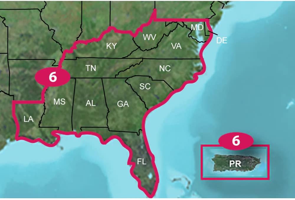
This is the 4th TOPO microSD/SD card I have purchased. To start with the good--it works in all the apparatus I want it to (PC, GPS, etc) the microsSD/SD combination ensures that. The data appears up to date although I am unable to check all trails, etc--details that others have reported missing in other maps areas (and I have noticed in my Atlantic area set). My big gripe and why I rate this as a 3 is that the card is advertised as having Idaho, Montana, Wyoming, North and South Dakota, Minnesota, and Iowa yet my card came with only Idaho, Montana, and Wyoming. Frankly I was only interested in those 3 states but paid what I thought was a higher amount for the additional states vs other 2-4 state coverages because this set came with the microSD/SD card. I think that Garmin has so many variations of these map coverages floating around that they themselves can't even keep them straight.
H**W
A little disappointed
I moved to western NC 3 years ago, I live in the Nantahala NF. I bought this mainly for hiking. I have a UTV so I drive on Forest service Roads to trail heads. There are miles of forest service roads and trails. A lot of loop trails off the Appalachian trail and trails to waterfalls and lookouts. After spending a week or so with the 24 topo inserted in my Garmin 66i I have noticed a dozen or so trails not on the map 1 trail will be crossing another trail not shown. So the 24 topo is good and if your blazing a new trail backwoods it will be very useful. But I don't understand why some long and established trails are not included.
L**C
Had one for years
Had one for years and it finally died. Got my husband a new one and he's in business again! Bought these extended maps so we can salt water fish in other places. He won't take the plastic off the screen to protect it more.
K**N
This card has been updated since the first one and shows a lot more roads and details.
There is nothing I disliked and if a person is going to explore the backcountry in Nevada were I am located at the moment one needs this SD. I also use it when I am in Washington State.
M**E
CD vs. SD cards
I needed the same features as the CD version, but was not aware that the SD card version did not have it. The CD version, once you insert it into your drive it automatically becomes part of basecamp and you don't ever have to put the CD in again to get the features that these TOPO maps provide. But with the SD card, it has to be inserted into your device, and the device has to be connected to your computer for it to work on basecamp. Blah......
J**L
A solid 4 stars, I think, based on a recent trip to the Cascades and Washington State. The two key downsides of this map are that it isn't routable, and that this edition is from 2016 so pretty out of date. On the plus side it has reliable trails and is fine for hiking navigation; and the key positive is that although the UK price is £70 or so, that's an average of under £2 per state, which is excellent value. If you need a routable map for transport you'll need Garmin's USA NT map or equivalent; for following routes (train, bus) and for hiking with direct routing or relating paths to the map it seems reliable despite the age of the revision, and very cost effective.
Trustpilot
2 days ago
3 days ago