We remain fully operational. Our teams are working around the clock to ensure your deliveries continue safely.

Descargar la aplicación


Servicios al cliente
Sobre nosotros
Copyright © 2025 Desertcart Holdings Limited
Descargar la aplicación


Buy anything from 5,000+ international stores. One checkout price. No surprise fees. Join 2M+ shoppers on Desertcart.
Desertcart purchases this item on your behalf and handles shipping, customs, and support to Spain.
🚀 Elevate your surveying game with the SMA26 Pro — precision, power, and ruggedness in one sleek package!
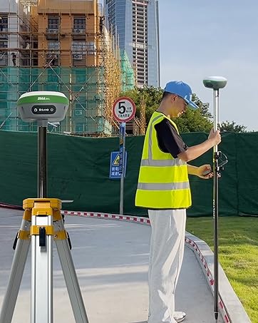
The SMA26 Pro GNSS Base Receiver is a cutting-edge RTK surveying system designed for professional land, construction, and forestry applications. Featuring full-constellation 4G RTK GNSS compatibility, wide protocol support, and advanced tilt compensation, it ensures high-precision measurements even in challenging environments. Its rugged IP67-rated design, 10000mAh battery with 20-hour runtime, and integrated connectivity options (Bluetooth, Wi-Fi, UHF radio) make it a versatile and reliable tool for modern surveyors seeking efficiency and accuracy.


| ASIN | B0BYCR3VQQ |
| Are Batteries Included? | Yes |
| Audio Output Mode | Digital |
| Battery Average Life | 2 days |
| Best Sellers Rank | 199 in GPS Module Receivers |
| Box Contents | GNSS Receiver, Handheld Collector, Other accessories |
| Brand Name | SMAJAYU |
| Compatible Devices | Smartphone |
| Compatible with Vehicle Type | Truck |
| Connectivity Protocol | Bluetooth |
| Control Method | App |
| Customer Reviews | 4.6 4.6 out of 5 stars (21) |
| Display Type | LCD |
| Human Interface Types | Buttons, Touchscreen |
| Item Dimensions L x W x H | 14L x 14W x 8.6H centimetres |
| Manufacturer | SMAJAYU |
| Map Coverage Type | Worldwide |
| Memory Storage Capacity | 32 GB |
| Model Name | LI-VZNI-VUBW |
| Model Year | 2024 |
| Mounting Type | Handheld |
| Network Connectivity Technology | Wi-Fi |
| Operating Systems | Android |
| Product Features | 51 alphanumeric keys on collector, Touchscreen, Waterproof |
| Product Warranty | 1 year |
| Resolution | 1408 |
| Screen Size | 5.5 Inches |
| Sport Type | Static and Movable |
| Supported Satellite Navigation System | BeiDou, GLONASS, GPS, Galileo |
| Touch Screen Type | Capacitive |
A**O
MUY BUEN PRODUCTO YA LLEVO MAS DE DOS MESE CON EL, EL GNSS R26 - V2 ES MUY BUEN PRODUCTO YA QUE TIENE CALIBRACION DE LA NOAA PARA PROCESOS PPP ARROJA MUY BUENOS RESULTADOS AUN EN CIUDAD Y A CIELO ABIERTO MUCHO MEJORES POR EL METODO ESTATICO. EN RTK LA UNIDAD DE MODULO INERCIAL ES DE GRAN AYUDA YA QUE HAY PUNTOS DIFICILES Y TE AYUDA MUY BIEN. EN RESUMEN UN EQUIPO QUE VALE MUCHO LA PENA ADQUIRIRLO.
D**K
We purchased this to be used in place of, or in supplement to, a total station for survey and mapping on an archaeological project. We had been hearing from colleagues for a few years now on the merits of a dGPS in an archaeological setting and this year we felt it was time to jump on the bandwagon. This product did not disappoint. First, I will admit that what drew our attention first and foremost is the price. The fact that we could purchase not one, but two units (one to serve as a base and the other as a rover) for less than $3K, which is what we would be paying for one decent used total station, was mind-blowing. Reading the reviews gave us pretty good confidence in the product, so we pulled the trigger. The reason why we're writing this review is, however, not because of how little it cost, but how well it performed in the field. It took literally minutes to figure out the settings, thanks to little details like voice notification from the units themselves, clarity of the UI of their software (SMA Survey), and some helpful videos on YouTube. As with any new ecosystem, it takes a while to figure out what's going on (it took a little while for us to work out how stakeouts work), but once there, everything became a breeze. We were collecting topo data at the speed of walking, literally. Tilt compensation is a game changer for mapping. We even tried laying out units (which we traditionally have used the total station for), which may not be quite as accurate as a TS but the time-savings may very well offset it. What perhaps may be of most value, however, is their support. Since we were slightly anxious about taking into the field not only a newly purchased product, but a new-to-us set of instruments, I contacted their support and they immediately set up a WhatsApp support thread with us so that we could make inquiries and usually get responses within 24 hours. Their dedication to making their products easy to use in device design, UI design, and support structure is, perhaps, the real winner here. Can definitely recommend.
G**W
Is very straightforward to use and customer support is available
A**O
Muy buen equipo GNSS, cuenta con muy buena precisión, compactos, graban rinex, son completos y lo que me gustó más fue su colectora, la medición de inclinación y su forma de replantear con camara con la colectora.
C**A
Excelente equipo de topografía, el software me encanta mucho. Lo mejor que he usado en GPS
Trustpilot
Hace 2 meses
Hace 1 mes