
Descargar la aplicación


Servicios al cliente
Sobre nosotros
Copyright © 2025 Desertcart Holdings Limited
Descargar la aplicación


🛥️ Navigate like a pro, float like a champ!
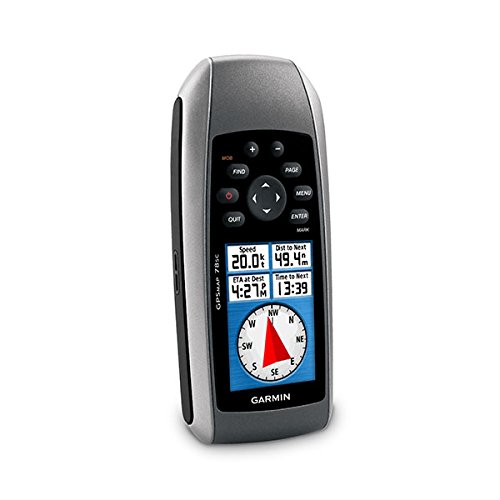
The Garmin GPSMAP 78S is a rugged, waterproof marine GPS navigator featuring a high-sensitivity GPS receiver, 3-axis tilt-compensated compass, and barometric altimeter. It comes preloaded with a worldwide basemap and supports additional maps via microSD cards. Designed for boaters and outdoor enthusiasts, it offers wireless waypoint sharing, geocaching support, and up to 20 hours of battery life, making it the ultimate companion for precise navigation on water and land.

| Item Weight | 7.7 Ounces |
| Item Dimensions L x W x H | 1.2"L x 2.6"W x 6"H |
| Battery Average Life | 20 Hours |
| Connectivity Technology | gpsmap |
| Control Method | Touch |
| Human-Interface Input | Buttons |
| Resolution | 160 x 240 |
| Compatible with Vehicle Type | Boat |
| Map Types | Worldwide |
| Connectivity Protocol | GPSmap |
| Display Type | LCD |
| Compatible Devices | Smartphone |
| Supported Satellite Navigation System | GPS |
| Mount Type | Dashboard Mount, found in image |
| Screen Size | 2.6 Inches |
| Memory Storage Capacity | 1724 MB |
| Are Batteries Included | Yes |
| Sport Type | Fishing |
| Additional Features | Rugged case, Garmin HotFix, Photo navigation, Barometric altimeter, Garmin Connect compatible, Electromagnetic compass, Custom POIs, Automatic routing, Hunt/fish calendar, Geocaching |
Trustpilot
Hace 4 días
Hace 3 semanas